Assignment:
- Research and find a credible map of a specific physical geography phenomena (from the lithosphere, biosphere, hydrosphere or atmosphere).
- Post a new reply to this discussion board with the map (as an attached .doc, .pdf, or functioning web link), and citation.
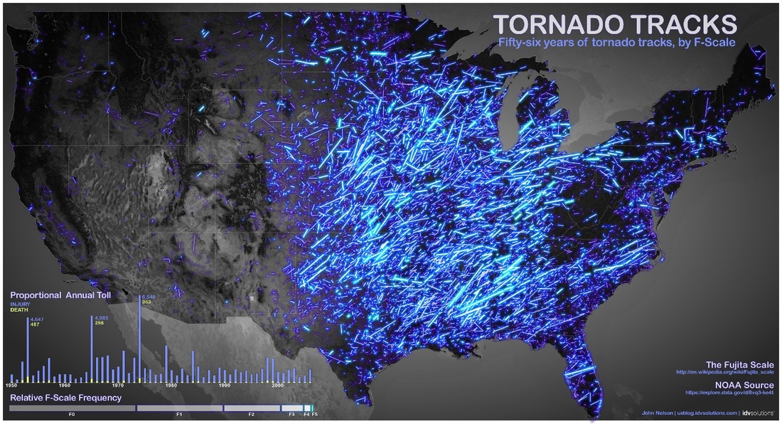
Map Source: A map made by John Nelson, the user experience and mapping manager for IDV Solutions, shows the paths of tornadoes that struck the United States between 1950 and 2006. The brightness of the line corresponds to the strength of the tornado. Credit: John Nelson, IDV Solutions.
Student Response to Map: This is a map that tracks and displays the occurrences of tornadoes all over the U.S. Looking at the map, the pattern that comes to mind is that tornadoes will most likely occur from the middle of the U.S to the East. The area that I believe has most tornadoes would be between about Texas to a little left of Florida. My hypothesis is that tornadoes occur around these regions because of the hot and cold area that interact with each other where cold pushes down from the north and hot pushing up from the south.
Student Response to Map: The map shows a clear pattern. I can observe that the pattern of tornado tracks and strength is notably higher in the Eastern States of the United States. Strength and frequency of tornados are very high in the states of Oklahoma, Nebraska, South Dakota, Kansas and Texas - also known as Tornado Alley to storm chasers. To the extent of my understanding, this may be due to the meeting of air of different temperatures, humidity's and pressure coming in from separate directions: these provide the conditions for strong and frequent tornadoes in the tornado alley.
Student Response to Map: The map shows a clear pattern. I can observe that the pattern of tornado tracks and strength is notably higher in the Eastern States of the United States. Strength and frequency of tornados are very high in the states of Oklahoma, Nebraska, South Dakota, Kansas and Texas - also known as Tornado Alley to storm chasers. To the extent of my understanding, this may be due to the meeting of air of different temperatures, humidity's and pressure coming in from separate directions: these provide the conditions for strong and frequent tornadoes in the tornado alley.
Personal Reflection of Assignment:
This assignment helped to build a foundation for this class through practice. Research, research, research. Most of this class has been about collecting information and interpreting what the information means. It was important to post timely on this assignment because each student was required to review the map of another student, analyze it and then post their interpretation. Above is the map I posted, can you analyze it? I felt this I felt the assignment went smoothly and the participating members of the class were helpful and punctual with responses. This helped to create a team and made the process stress free and allowed for a complete learning experience. This assignment helped me gain a strong understanding of the components of analyzing data when it was my turn to interpret classmate's maps.
